


Two earthquakes have struck near Los Angeles, one at 11:27 PM (local time) last night and the other about 15 minutes ago at 11:10 AM (local time) today. The first was a magnitude 4.1, the second was a 2.6
Both quakes took place in exactly the location we warned about two weeks ago, along the exact fault lines we warned about (San Andreas and Elsinore faults), within the exact time frame we warned about, 2 weeks! Here is the story which appeared here on SuperStation95 issuing the warning.

A massive burst of Carbon Monoxide gas suddenly came out of the seismic faults in California around February 27; so much that it was picked up by satellites in space! We reported this and cited a scientific paper to conclude that an earthquake was coming, would take place within two weeks, and people should prepare. That initial story appeared HERE
NASA was quick to counter the alert, saying the satellite was “in error” and the release of gas didn’t really happen. Snopes.com called the story “mostly fake.” Local news media in Los Angeles did a story about our story and told folks there was nothing to be concerned about.
But NASA’s statement contradicted a statement made on SuperStation95 by Geophysics Professor Ramesh Singh, who wrote a scientific paper published in the Journal Geophysics in April, 2010.
Professor Singh, from Chapman University in Orange, CA, showed conclusively in his paper that a sudden surge of certain gases from the ground, could, in fact, be a pre-earthquake warning sign. It doesn’t always happen, but depending upon what’s underground in a given area, it CAN be a sign. His interview on “The Hal Turner Show” is available (free) HERE
Here we are, just short of two weeks later, two earthquakes have struck southern California is the exact place the Carbon Monoxide gas was emitted, from the exact faults cited in our initial report (San Andreas and Elsinore), and within the exact time frame of “two weeks” that our report first told readers.
Related: Coming Soon? This Is What Would Happen If A 9.0 Earthquake Hit The Cascadia Subduction Zone…
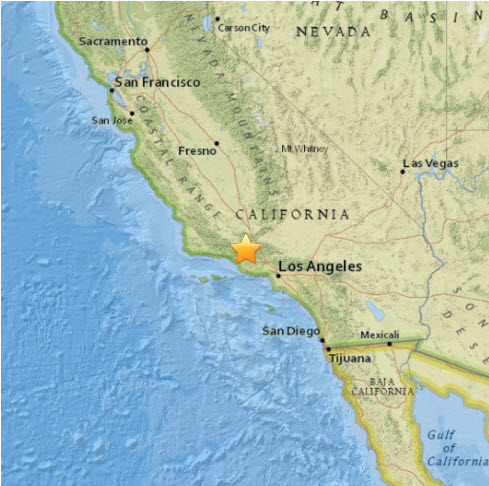
The Magnitude 4.1 Quake is shown here by the US Geological Survey on the map below. CLICK THE MAP to get the USGS report:

The magnitude 2.6 quake, which took place within the hour, is shown on this other map from USGS. CLICK THE MAP for USGS report:

source:superstation95.com