


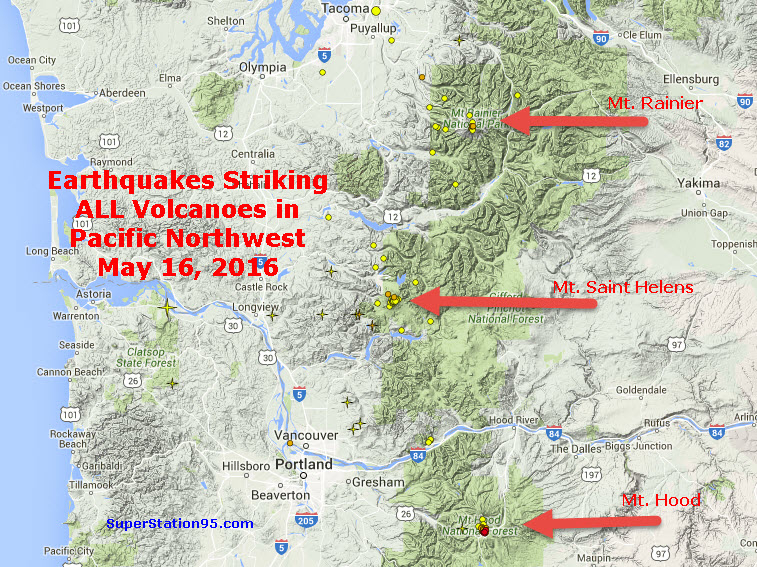
Last week, the world was told that Mt. Saint Helens was experiencing earthquakes. Now, two other nearby volcanoes, Mt. Hood and Mt. Rainier are also having quakes!
Last week, according to the Pacific Northwest Seismic Network (PNSN), the world was informed (via 19,000 stories) that Mt. Saint Helens was “recharging.” While scientists were explicitly clear there is NO SIGN OF IMMINENT ERUPTION, they pointed out that there had been more than 130 earthquakes, between 1.2 and 4 miles deep, in the area from March 14 thru May 2.
Fast forward about two weeks to today, May 16, and we now find the number of earthquakes is not only increasing, there are new earthquakes taking place at TWO ADDITIONAL VOLCANOES, Mt. Hood and Mt. Rainier!
The images below tell the story.
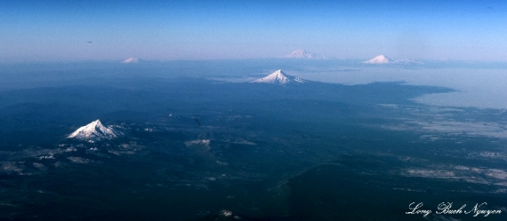
First, a look at where these volcanoes are located. Click any image to enlarge:
Mt. Saint Helens
We will begin in the middle, with Mt. Saint Helens, since it’s been in the news lately. The split-image below shows what the mountain looked life BEFORE the 1980 eruption (left) and AFTER the eruption (right):
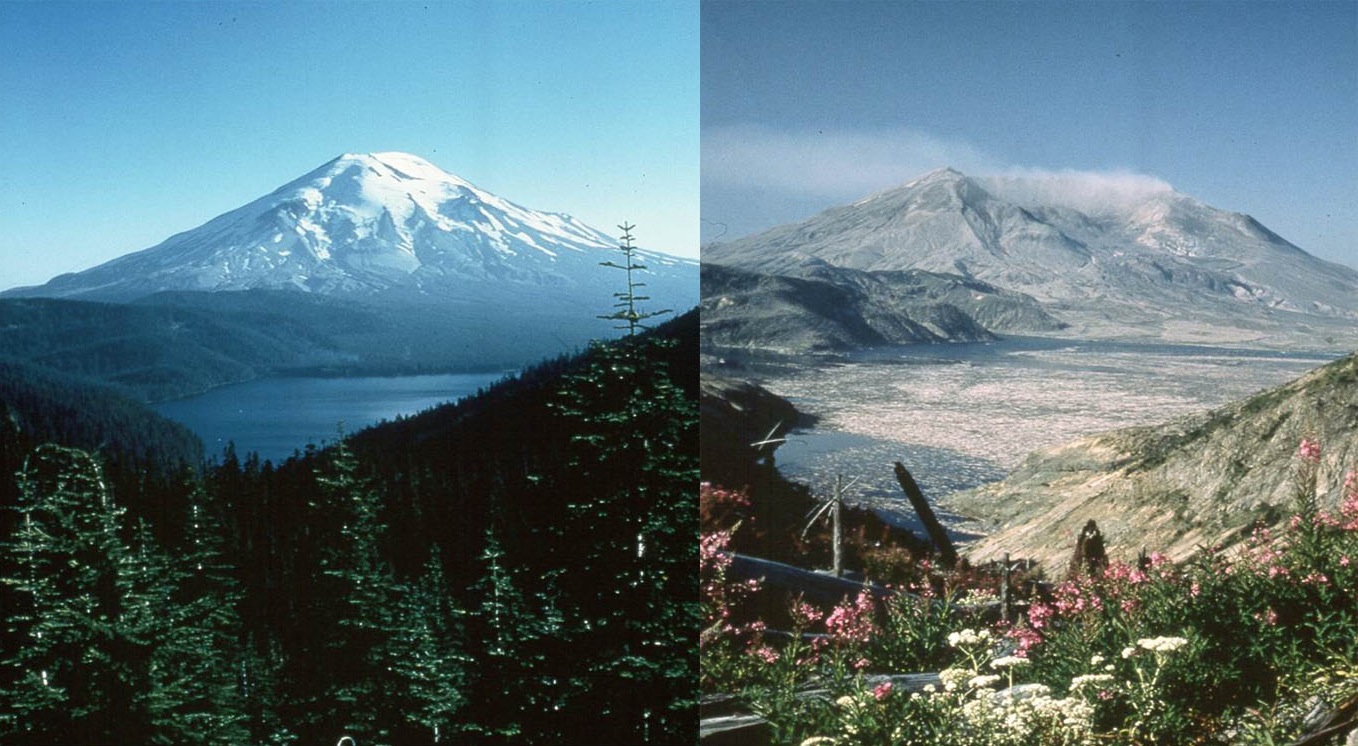
Notice the beautiful forest for miles and the magnificent lake in the left photo; which was all totally destroyed after the eruption in the right photo. This is the mind-boggling power of one of these volcanoes; it can destroy everything in its path for miles.
And what just happens to be in its path? Portland. Here’s an image showing Mt. St. Helens from Portland, OR
Below is an image from the PNSN showing quakes at Mt. Saint Helens TODAY:
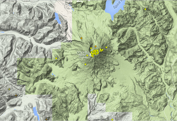
Notice where the earthquakes are taking place? Right smack in the middle of the mouth of the volcano! The “Caldera!”
Here’s how the PNSN Seismograph recorded the earthquake activity at Mt. Saint Helens TODAY:
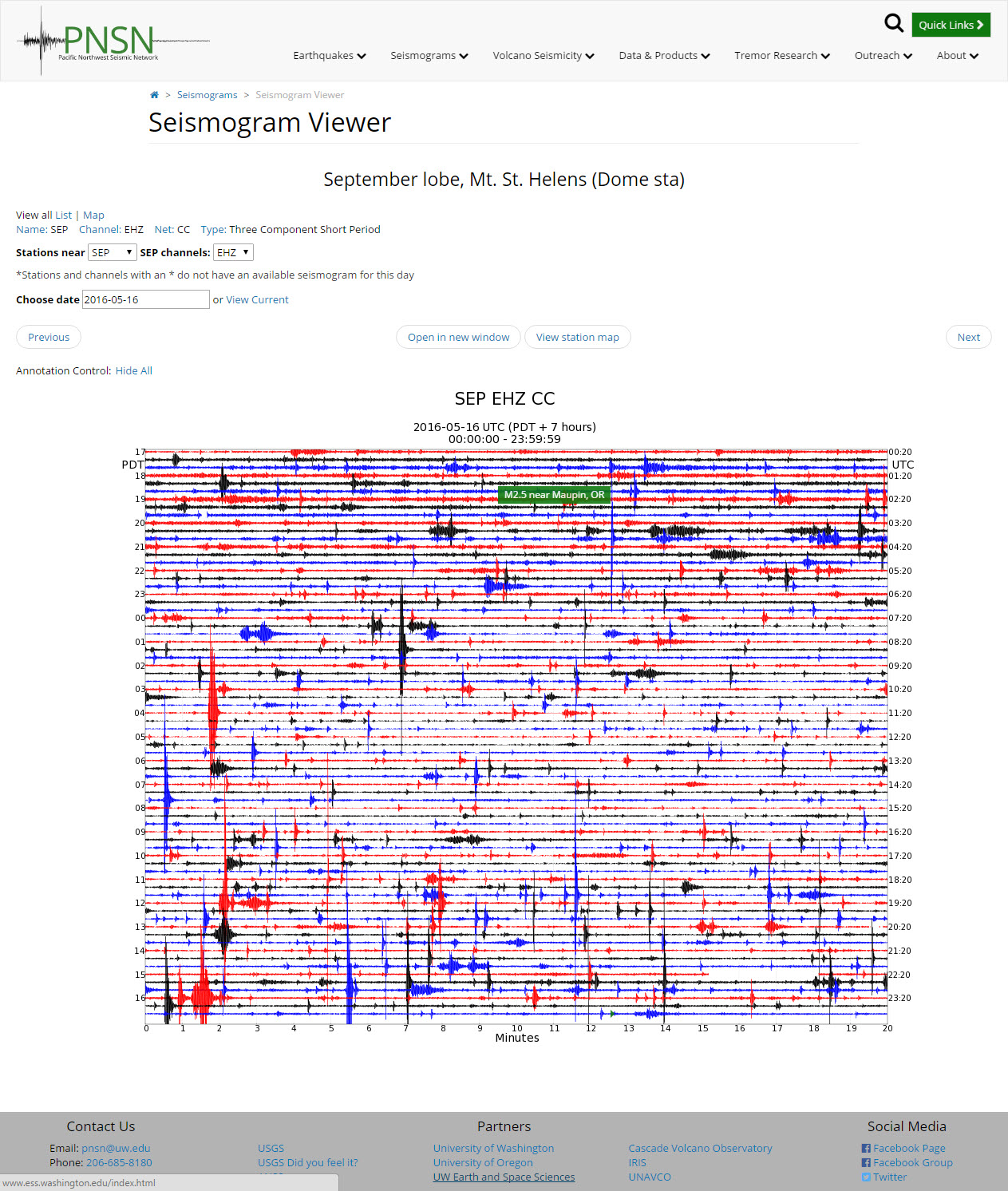
Looks like there’s “a whole lot a shakin’ goin’ on!”
Mt. Rainier
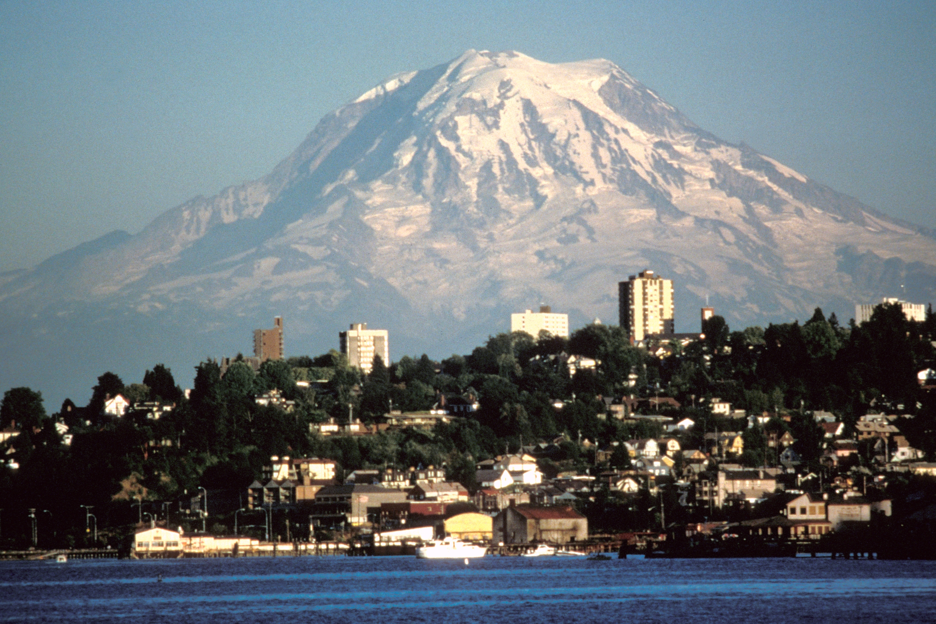
The image below shows Mt. Rainier in all it’s awesome magnificence, towering above Tacoma, WA:
We now see earthquake activity in the Caldera of Mt. Rainier to the North!
As above, the image tells the story. The image below shows the earthquake activity at Mt. Rainier TODAY:
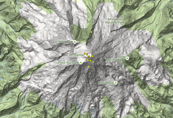
As with Mt. Saint Helens, these earthquakes at Mt. Rainier are taking place high-up in the volcano itself, near the Caldera.
The image below shows how the PNSN seismographs recorded the earthquakes at Mt. Rainier TODAY:
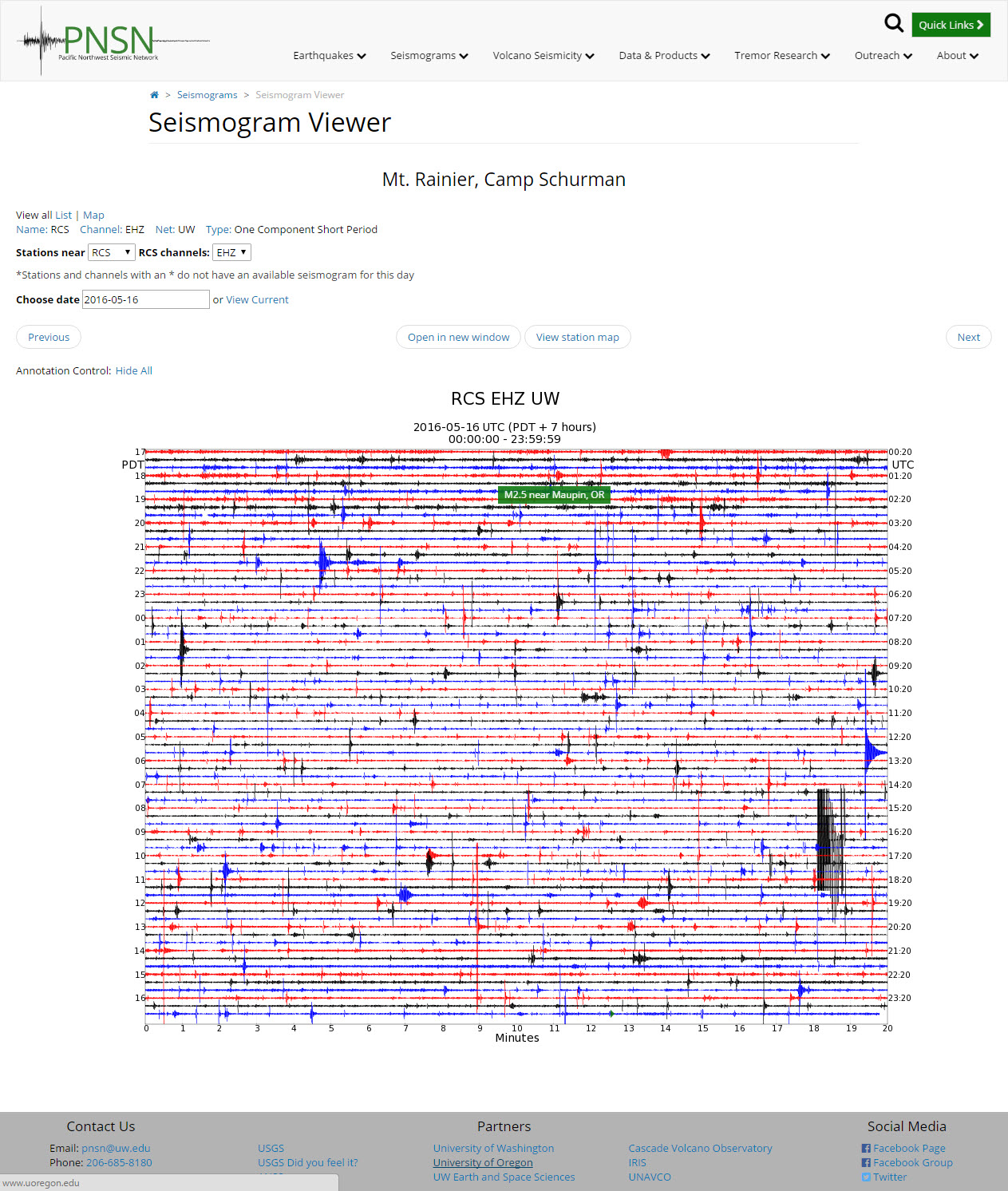
That’s a lot of earthquakes for one day!
Is the next major volcanic eruption in the United States just around the corner? Mount St. Helens and the Yellowstone supervolcano get most of the attention, but many geologists are actually far more concerned about the potential danger that Mt. Rainier poses. It has been called a “time bomb“, “the most dangerous mountain in the United States” and “one of the most dangerous volcanoes in the world” due to its proximity to major population centers. Scientists tell us that it is a matter of WHEN, not if, the next eruption will happen, and even a minor eruption could result in tens of thousands of Americans being literally buried alive in super-heated mud. So what would a full-blown eruption do? It would potentially cause death and destruction on a scale that is almost unimaginable.

On May 18th, 1980, Mount St. Helens erupted with the power of 500 Hiroshima bombs. At the time, very few scientists anticipated that Mount St. Helens was capable of such a powerful eruption. But Mount St. Helens is not even the most dangerous volcano in the state of Washington. If Mount Rainier were to erupt with the same force that Mount St. Helens erupted in 1980, the loss of life would be far, far greater. The following comes from Wikipedia…
If Mt. Rainier were to erupt as powerfully as Mount St. Helensdid in its May 18, 1980, eruption, the effect would be cumulatively greater, because of the far more massive amounts of glacial ice locked on the volcano compared to Mount St. Helens[33] and the vastly more heavily populated areas surrounding Rainier.[38] Lahars from Rainier pose the most risk to life and property,[39] as many communities lie atop older lahar deposits. According to the United States Geological Survey (USGS), about 150,000 people live on top of old lahar deposits of Rainier.[8] Not only is there much ice atop the volcano, the volcano is also slowly being weakened by hydrothermal activity. According to Geoff Clayton, a geologist with a Washington State Geology firm, RH2 Engineering, a repeat of the Osceola mudflow would destroy Enumclaw,Orting, Kent, Auburn, Puyallup, Sumner and all of Renton.[32] Such a mudflow might also reach down the Duwamishestuary and destroy parts of downtown Seattle, and causetsunamis in Puget Sound and Lake Washington.[40] Rainier is also capable of producing pyroclastic flows and expelling lava.
Most people don’t even know what “lahars” are, but they can be exceedingly deadly. Just imagine a tsunami of super-heated mud that is hundreds of feet thick traveling at highway speeds. In fact, scientists believe that Mount Rainier is capable of producing massive lahars that could move at speeds of up to 50 miles per hour…
Heat from an eruption will melt ice and glaciers on the mountain and turn them into mudslides moving up to 50 mph, with the potential to be more than 400 feet deep in nearby valleys. Rainier has had a history of lahars, ranging from more than 5,600 years ago to only 500 years ago.
The largest of these debris flows – the Osceola Mudflow – occurred 5,600 years ago, covered 212 square miles of land from Rainier to Kent and was hundreds of feet deep.
The cities near Mount Rainier have early warning systems, but the truth is that once a lahar is unleashed it would be necessary to evacuate hundreds of thousands of people from the region in less than an hour. Does anyone actually believe that would be possible? Here is how one author described the danger that residents could potentially be facing…
The numerous towns and cities that occupy the surrounding valley would all be at risk for not only severe destruction, but complete annihilation. Residents of cities like Orting, Sumner, Buckley, and Enumclaw are estimated to have no more than 30 minutes before the lahar, speeding down from the many rivers that flow from Mount Rainier, buries their homes and businesses beneath as much as 30 feet of mud and debris. Even the larger cities like Auburn, Puyallup, and Tacoma itself are not safe. Auburn and Puyallup, with nearly 80,000 residents between them, would be covered in 20 feet of mud in less than an hour, and Tacoma, at almost 200,000, is estimated to be hit with nearly 10 feet from the lahar.
It is hard to even come up with the words to describe how horrific this would be. It would literally be a “river of death” hundreds of feet high burying everything in its path in super-heated mud. Once a lahar is within sight, there is no possibility of outrunning it. The only hope would be to get to high ground in time.
Related: Major Eruption Imminent? Earthquake Swarms Reported At Mt. Hood, Mt. Rainier And Mt. St. Helens
If Mount Rainier were to experience a full-blown eruption today, it would likely be the worst natural disaster in U.S. history up to this point by far. And scientists tell us that such an event is inevitable…
The nature of this impending and INEVITABLE tsunami is, this isn’t just water flowing, this is giant boulders, whole houses, a million huge trees, cars, ships, people, cows, we saw this in Japan recently, all smashing along relentlessly and not ending in a minute or an hour, but going on and on and on, piling into narrow bays and pinned in by high hillsides…this makes the tsunamis WORSE, not safer!
The Puget Sound bay is not that deep. So the resulting multiple high flood events pouring into several parts of the Puget Sound will cause a huge wave to jump ahead of the flood and the bulky mess of debris pouring in will displace more water and it will flood huge areas that are at sea level and even, like in Japan, make huge waves smashing up hillsides, wiping out everything, tearing down trees, rocks and buildings.
Once this wave of destruction hits, no one will be able to save others because it will go on and on and on for several hours at least.
Those that have studied Mount Rainier tell us that there is evidence that the mountain has produced at least 60 lahars in the past.
And according to the Seattle Times, there is a “one in seven” chance that Mount Rainier will produce another one within our lifetimes…
Chances are one in seven – worse than the odds of having a house fire – that a moderate lahar will happen in a person’s lifetime.
But these are not normal times.
Mount Rainier lies along the Ring of Fire, and right now volcanoes all along the Ring of Fire are waking up.

Mt. Hood
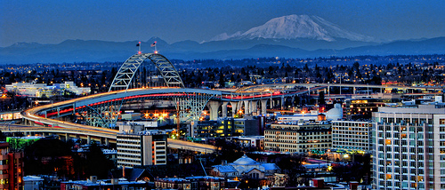
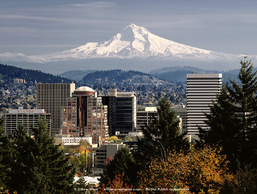
The image below shows Mt. Hood, as it rises gloriously above Portland, OR:
To the south, just over the border into Oregon, Mt. Hood has stood silent for a long, long time. That silence has ended.
Below is the image showing earthquakes beginning deep beneath Mt. Hood and to the south of it’s caldera. Those deep quakes are Magma moving, from deep inside the earth. Take a look:
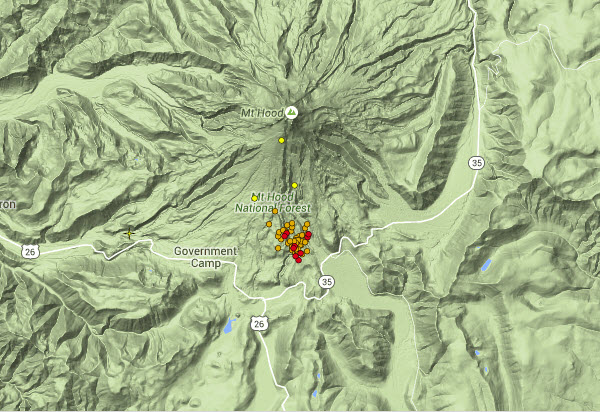
This is an interesting (if not worrisome) situation. The quakes are all on the SOUTH side of Mt. Hood. Those of you who recall the famous Mt. Saint Helens eruption back in 1980, will remember that it was the entire SOUTH side of that volcano which blew off. Now, Mt. Hood is acting up . . . on its SOUTH side!
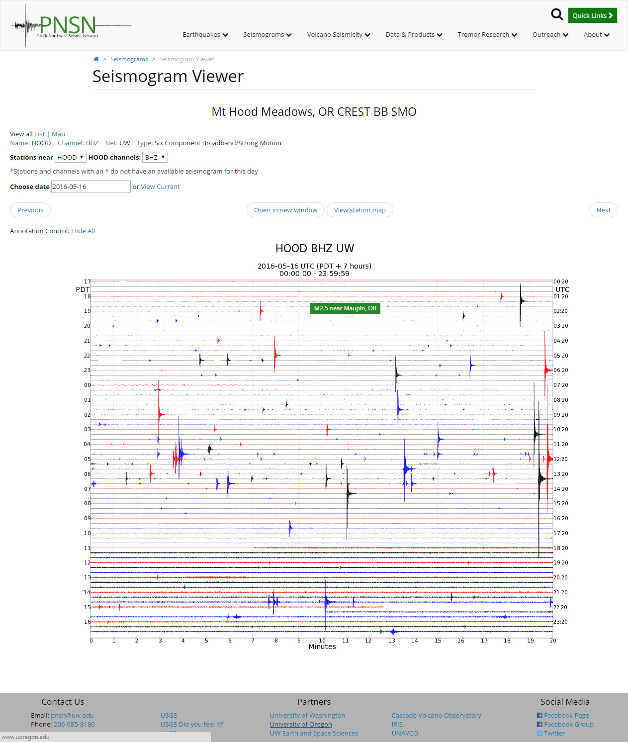
Here’s how the seismographs from the PNSN recorded the earthquake activity at Mt. Hood TODAY:
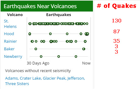
And if this isn’t bad enough, two additional local volcanoes have also begun showing minimal, but new, earthquake activity: Mt. Baker and Mt. Newberry! The chart below show the number of quakes at each volcano for the past thirty days:
SUGGESTED PREPARATION
Scientists have made it very clear that NONE of these volcanoes is showing any signs off imminent eruption. But those on the west coast would be very well advised to keep a sharp eye and have an pre-planned evacuation route.
If St. Helens erupts, we go this way. If Rainier erupts, we go that way. If Mt. Hood erupts, we go this other way.. If, (God forbid) all three erupt, we go . . . . you get the idea.
It is important to bear in mind that you are not alone in having plans to leave and much to your dire surprise, you may find all the highways jammed. So plan alternate routes. Have each of your cars equipped with a CB radio and magnet mount antenna so you can get on the spot traffic updates while you’re on the road, and get instant info from other drivers.
Make sure your cars and your home have N-95 or N-100 filter masks to protect your lungs from deadly volcanic ash. Volcanic ash is not really “ash” like a cigarette gives off; it is actually pulverized rock. If it gets in your moist lungs, it becomes mud. Your body cannot cleanse this and if you get too big a whiff, you literally drown on the mud in your lungs. So have filter masks for yourself and each member of your family. YOU MUST BE CLEAN-SHAVEN FOR THESE MASKS TO WORK. They will not be effective for men with stubble or beards!
Have waterproof goggles, even cheap swimmer goggles, for yourself and each member of your family, You need these to keep volcanic ash out of your eyes. Again, volcanic ash is actually pulverized rock which, if it gets in your eyes, will scratch your eye lenses.
Would you be able to sustain your loved ones when all hell brakes loose?In this video, I will unearth a long-forgotten secret that helped our ancestors survive famines, wars, economic crises, diseases, droughts, and anything else life threw at them… a secret that will help you do the same for your loved ones when America crumbles into the ground.I’m also going to share with you three old lessons that will ensure your children will be well fed when others are rummaging through garbage bins.Watch the video below to learn all about the 3 skills that will help you thrive in any crises situation:

Volcanic ash will clog car air-intake filters and stall your vehicle. Have a spare air filter or two IN YOUR TRUNK to make certain you can change to a clean filter if your car stalls while you’re evacuating. A clean filter will get you quite a few more miles farther away.
Have “Go bags” with some change of clothes, medicine(s) you may need to survive and some food/water to take along the way.
Keep your car gas tank at least HALF FULL at all times; there won’t be any time at all for you to stop for fuel if one of these volcanoes erupts.
Your very life may depend on these simple acts. Plan wisely.
by Newsroom
Not that it matters all that much, but it was the NORTH face of Mount St. Helens that blew, not the SOUTH as you state in the article when speaking of earthquakes on the south side of Mt. Hood.
Wow ohhhhhhhh Wowsa
So what, I worry more about 3 volcano’s could blow at any time. Instead of how 1 blew in 1980 it’s 2016.
I began my comment with Not that it matters all that much,” because in the grand scheme of things, if they blow, especially all three or the supervolcano at Yellowstone blows, quibbling over which side of Mount St. Helens blew out in 1980 isn’t that important. However, in the spirit of accurate journalism and publishing correct information, it is important to get the facts correct.
Try that one more time- and this time try to make a coherent statement.
WE had ash in Vancouver, B.C. which is north definitely.
We had ash down the Wilamette Valley as well which is south.
The point being that it’s wind patterns that determine where ash falls at such distances.
We had 1/4 inch of ash in Montana
There was NO ash in Bremerton When St. Helens blew.
I was going to say the same thing. I hike St.Helens all the time during the summer and ride my snowmobiles there during the winter. I’m pretty sure that it is the north side of the mountain that is “missing.” I would be worried if Mt.Adams (45 miles east of Hellens) started to act up. Only because of the proximity of 3 volcanos with all the size and glaciers that they possess. That could really make things difficult.
Here is one of several links for info on the eruption of north face of Mount St. Helens on May 18, 1980.
http://www.mountsthelens.com/history-1.html
Any idea about when?
Like, any ol’ time. these earthquakes show nothing. All three volcanos have rumbled for millenia, there ain’t more now then there. Mount Saint Helens erupted three time in the 1800s, once last century, and none so far this one. the trend is no eruptions in established mountains, but somewhere in the central plains south of Olympia.
Mt. St. Helens has already had three volcanic eruptions this millennium:
● October 1, 2004
● March 8, 2005
● December 19, 2006
Please see the following link for more details.
https://en.wikipedia.org/wiki/2004%E2%80%9308_volcanic_activity_of_Mount_St._Helens
There are two kinds of volcanic earthquakes, volcano-tectonic, and long period also called volanic tenor. Tectonic earthquakes are caused by rock moving to fill in spaces where the magma is no longer present. These types of earthquakes do not indicate that a volcano will be erupting but can occur at any time. However the long period earthquakes or volcanic Tanner are early warning signs that the magma chamber is filling up with magma and when these types of earthquakes happen more people feel them they’re not located just around the mountain they actually move out into the communities that are surrounding the mountain so when we start feeling those earthquakes the emergency alert systems will be telling us in advance and we will have probably weeks to be able to move away from the mountains when it looks like they’re about to explode. the Mount Saint Helens eruption was one that was we were able to get weeks in advance knowledge that the mountain were going to erupt. it’s a good thing to always be prepared but I really don’t think that we need to be scared. the earthquakes at Mount Hood look like that could be something that is happening there but probably like we’re very early stages of the magma chamber filling up and that’s going to be kind of interesting. Would like more input about this statement, thank you
Well, point taken, especially considering our understanding of and ability to detect both volcanic eruptions and earthquakes is so advanced….
As I recall, Hood is the same type of volcano as St Helens, it will explode. The weak side is toward Portland. While the ash cloud will travel east, the pyroclastic flow will take out Portland and a good chunk of the Willamette Valley. I’ve heard the warnings my whole life that Hood is unpredictable, it can go with little warning. Yellowstone is also an exploding type volcano. If it goes, you can kiss most of the grain belt goodbye. So, do we worry, buy bunches of supplies, go total prepped? I’ll take reasonable precautions but in reality, we’re going to be ground volcano burgers when these things start exploding
Agenda 21 strikes again. And it’s not a conspiracy theory. Please folks, look it up, only not on the Wikipedia article – they still use pretty words like depopulation instead of genocide or murder. See what attorney Michael Shaw has to say about it, or Australian politician Ann Bressington. It’s all online for now but politicians will probably be taking it down soon as too many people are catching on to what they’re up to.
Why worry about genocide via volcano? We’re going to do it to ourselves…. the easiest way to depopulate the planet is to just let it happen. 7.5 billion people on the planet now. 13 billion by 2100. There are so many ways that are far easier than all the theories that are supposed to be Agenda 21 plots. Why make everything so complicated?
Yes, I always go to lawyers when trying to get scientific and geologic information. Agenda 21? I’m surprised you had enough intelligence to learn to type.
“No imminent signs of eruption”………that’s what they said last time (St. Helens)
Actually…. they never said that.
Whoever wrote this article needs to take an introduction to geology course. The use of the word “caldera” is so overused I cannot take anything you wrote seriously. You talk about the calderas of Ranier and Hood…. but then call Newberry Crater, “Mount Newberry. ” Please do your research….
Mt St Helens blew on the North side. I lived in Portland when it blew. I saw it from the first blast of steam & then the big event. I heard the explosion & saw the total main eruption, then it kept going all day headed North East. My mother in Spokane Washington was on the Silver lake fishing when the ash fell & turned day to night. Portland did eventually get up to 1/4 inch of ash when a minor eruption was caught in south winds & hit Portland. that was a mess to clean up. Yakima Washington got hit with ash fallout very hard…. Definitely blew north…..
You missed one: Goat Rocks
Once thought extinct, Goat Rocks, between Rainier and St Helens, has been found to have been responsible for eruptions which we had mistaken as one from its neighbor to the south only 140 years ago. And if you check it’s seismic activity, it is more active than these three.
Got a link showing recent activity? Everything I have seen says over 500,000 years or so.
Ok I guess we can dismiss the goat rocks story.
I am a citizen of Spokane, but now reside in Las Vegas area, we were there for an earthquake in Hangman Valley about 10 miles from us . The shock waves were like explosives going off. My first thought was that it was a math lab that exploded but the aftershocks continued for a long period, a shocking experience to say the least,….. I think of all the millions of people who will be affected by the scenario you predict. We relocated to Nevada for health reasons and I know how difficult and costly relocation is, but I would urge fellow citizens to do so if at all possible. I feel safe here but the truth be told this Valley of Las Vegas is surrounded by mountain and 7 fault lines to our east and west of us there are extinct volcano with numerous fault lines we can feel the tremors at night when it’s calm and no sound of machines or traffic. I am delighted however that we do not have Ocean with in close proximity so no worries there. There is in fact a water shortage, and that is our main concern. It seems nature is in charge.
If the mountains don’t kill us, something else will. We live on a planet that is ever-active. It has its own seasons and they take much longer than four months a piece. Relax. Enjoy. Mother-Earth do what she must. Maybe she’s angry over the many ways we abuse her.
Mt. St. Helens gave the experts lots of reason to believe that she would blow in a “short” time. I think the majority of the “experts” dismissed the idea. One of the main “BELIEVERS” died on the mountain, because he was dedicated to monitoring the geological patterns, symptoms, etc. to the bitter end. He was one very conscientious and dedicated scientist. Others mocked him, rejected the evidence, and went away with disdain. One other geologist traveled to eastern Oregon shortly before May 18th. He was outdoors, and heard the noise, and turned towards the blast, knowing full-well what had just happened. Unfortunately, most people will not heed the warnings. Geologists have been telling the people living in and moving into Orting, that it’s only a matter of time that the town will be buried, but it thrives (for now) anyway.