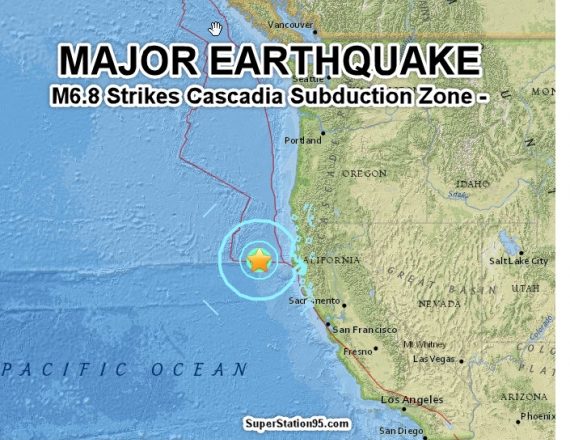


A VERY strong magnitude 6.8 earthquake (now re-calibrated lower to 6.5) has struck California in the Pacific Ocean at the dangerous “Cascadia Subduction Zone” 157 km west of Ferndale, CA. This is the exact area where “the big one” will begin if it happens, and a 6.5 quake can trigger it!
According to the US Geological Survey, the quake struck at 9:50 AM eastern US time (0650 local time) at a very shallow depth of only 12 km.

Initially a Tsunami concern existed but the Pacific Tsunami Warning Center has reported NO TSUNAMI from this earthquake. (Report below)
There is grave danger that today’s quake may be a “foreshock” and that it signals the coming of a much stronger, horrific, earthquake, within the next few days. Such a catastrophic quake can now be triggered in the Cascadia subduction zone because today’s quake has destabilized the region. People on the US west coast are URGED to prepare for such a potential emergency by storing food, water, batteries for flashlights and radios, fueling up their cars in case evacuation is needed. Have a plan!
TSUNAMI BUOY TRIGGERED
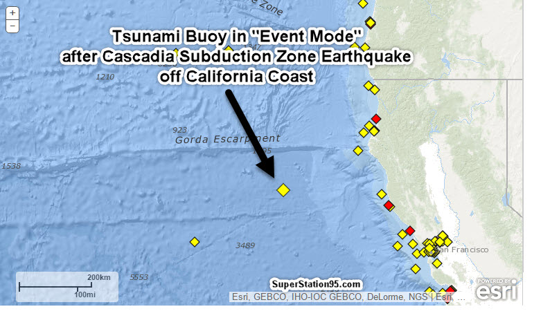
Here’s what the Tsunami Buoy “saw” with the ocean depth as the earthquake struck:
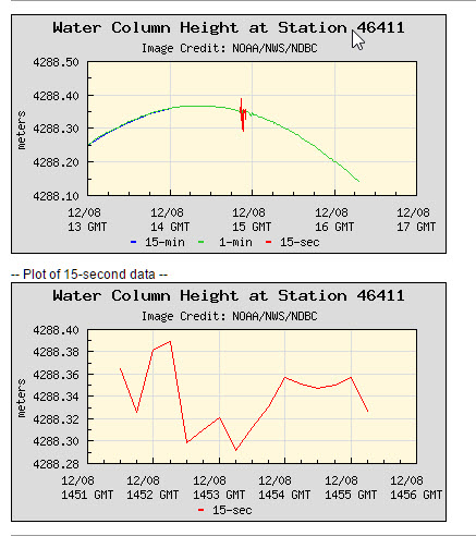
The red lines show a sudden and significant possible change in ocean depth, triggering the “Alert” into “Event Mode” which caused the Tsunami Center to make a report, below:
WEAK53 PAAQ 081453
TIBAK1

Tsunami Information Statement Number 1
NWS National Tsunami Warning Center Palmer AK
653 AM PST Thu Dec 8 2016

...THIS IS A TSUNAMI INFORMATION STATEMENT FOR ALASKA, BRITISH
   COLUMBIA, WASHINGTON, OREGON AND CALIFORNIA...

EVALUATION
----------
 * There is no tsunami danger for the areas listed above.

 * Based on earthquake information and historic tsunami records
   the earthquake was not sufficient to generate a tsunami.

 * An earthquake has occurred with parameters listed below.


PRELIMINARY EARTHQUAKE PARAMETERS
---------------------------------
 * The following parameters are based on a rapid preliminary
   assessment and changes may occur.

 * Magnitude      6.8
 * Origin Time    0550 AKST Dec 08 2016
                  0650  PST Dec 08 2016
                  1450  UTC Dec 08 2016
 * Coordinates    40.4 North 126.2 West
 * Depth          6 miles
 * Location       110 miles SW of Eureka, California
                  270 miles NW of San Francisco, California


ADDITIONAL INFORMATION AND NEXT UPDATE
--------------------------------------
 * Refer to the internet site ntwc.arh.noaa.gov for
   additional information.

 * Pacific coastal regions outside California, Oregon,
   Washington, British Columbia and Alaska should refer to the
   Pacific Tsunami Warning Center messages at ptwc.weather.gov.

 * This will be the only U.S. National Tsunami Warning center
   message for this event unless additional information becomes
   available.

$$

It is very important for the public to understand that a major earthquake such as this one, which takes place without any prior, smaller quakes, can be a sign that a much larger earthquake is coming.
For instance, in early March, 2011 off the coast of Japan, a sudden Magnitude 7 quake struck. It was followed less than two days later, by a devastating Magnitude 9.2 earthquake, which generated a huge Tsunami, that enveloped much of Japan’s coastline, triggering the meltdown and explosion of three reactors at the Fukushima Daiichi Nuclear Power Plant.
The fact that today’s 6.5 quake was not preceded by smaller quakes, could mean that a much larger earthquake is coming. The region is now destabilized from today’s quake and that is a very bad thing.
People along the west coast of North America, particularly those in California, Oregon and Washington state, are URGED to have plans to contact family members via Citizens Band (CB) radio, Amateur (Ham) Radio or other means in case phone lines and cellular service is cut by a major earthquake. You should make arrangements to be able to survive for several weeks with stored, CANNED food and water, have batteries for flashlights and portable radios and have vehicles fueled-up in case an evacuation becomes necessary.
Are you ready to turn back the clocks to the 1800s for up to three years?Because this is what will happen after the next SHTF event.Watch the video and spread the knowledge:

This Zone is where “The Big One” would start
For years Northern Californians have been warned that a big one could hit anytime on the San Andreas fault, but a potentially more dangerous quake and tsunami risk could be lurking off of the north coast.
The Cascadia Subduction Zone, which sits about 100 miles off shore, runs from California to Vancouver. The subduction zone is believed to have caused a 9.0 earthquake in 1700, the largest known quake ever to have hit the lower 48 states.
“The earthquake set off a tsunami that not only struck Cascadia’s Pacific coast, but also crossed the Pacific Ocean to Japan, where it damaged coastal villages. Written records of the damage in Japan pinpoint the earthquake to the evening of January 26, 1700,” according to the United States Geological Survey account of the quake.
In 2015, a group studying the region released a study of the potential damage of such a quake hitting now.
“The Cascadia subduction zone could produce an earthquake as large as the magnitude 9.0 event that devastated the east coast of Japan in 2011,” reads the report from the Cascadia Region Earthquake Workgroup, which says such a quake would likely have a lower death toll than the Japanese quake due to our relatively sparse population along much of our coastline.
The quake risk is so great because the West Coast sits largely on the North American Plate, but it is being continuously pushed against a series of plates in the Pacific: the Juan de Fuca Plate off the coasts of Washington and Oregon, the Explorer Plate off British Columbia, and the Gorda Plate off northern California. The study points out that the Juan de Fuca, Explorer, and Gorda plates contain denser rock than the North American Plate and are driven beneath it in a process known as subduction.
“The earthquake that many scientists and emergency planners anticipate is modeled on the zone’s last major quake: the entire fault zone ruptures from end to end, causing one great earthquake measuring magnitude 9.0,” reads the CREW study. “The ground is expected to go on shaking for four to six minutes.”
That destructive force would likely be followed within minutes by an equally dangerous tsunami similar to the Indian Ocean waves that killed 230,000 people a decade ago.
“Once it hits shore, a single tsunami wave can take as much as an hour to finish flowing in. The height of the wave and how far inland it travels will vary with location: In places along Cascadia’s coast, the tsunami may be as high as 30–40 feet,” reads the report.
In Seattle, Vasily Titov leads a team of scientists at the National Oceanic and Atmospheric Administration which studies this movement and looks for ways to warn coastal residents of such a wave.
SuperStation95 asked him about the warning technology, “On the San Andreas fault, we’re waiting for the big one. On the Cascadia fault, we’re waiting for the really big one?”
“That’s a very good way to put it…Looking at the video recordings in Japan, you may picture what will happen in our coastlines.”
His team is working to enhance the warning system in the event of a tsunami. Recent quakes have shown success in their latest tsunami warning system.

No such system was in place 50 years ago this month when a massive magnitude 9.2 earthquake hit Alaska, generating a tsunami that wiped out much of Crescent City. Since then researchers have made great strides in quake and tsunami detection, but implementing those tools has proven difficult and costly.
“I can tell you that we do have technology to produce very accurate and…[a] timely forecast. The science is there. Implementing the science into operations is a huge task,” said Titov.
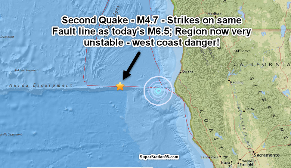
SECOND QUAKE HAS JUST STRUCK SAME AREA!
A second earthquake has just struck along the exact same fault line as today’s magnitude 6.5. The second quake, a smaller magnitude 4.7, stuck at a shallow depth of only 3.7 km and did so west of the initial M6.5, which means the instability is traveling west . . .toward the major Cascadia Subduction Zone main fault!!!! The map below shows the second earthquake at 11:30 AM eastern US time