


UPDATED with NASA Statement as of 8:20 PM on 1 March 2016 . See bottom — Beginning on February 26, NASA satellites in space began detecting staggeringly large emissions of Carbon Monoxide (CO) gas along the west coast, from Vancouver, British Columbia, Canada, all the way south to San Diego, CA.
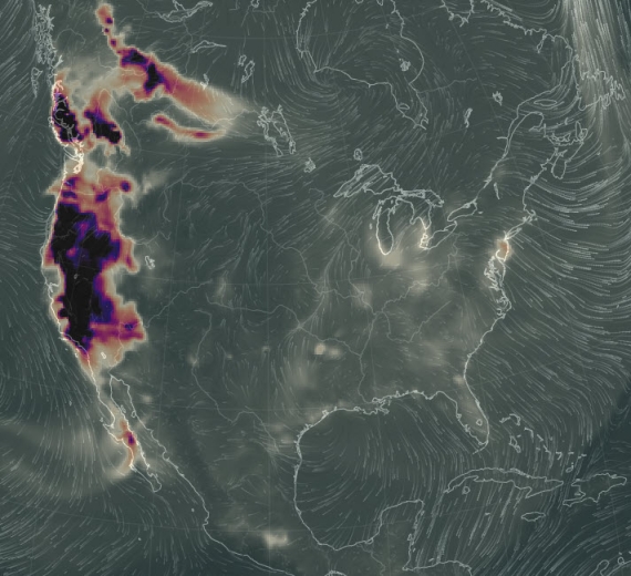
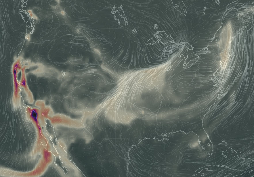
As evidenced by the satellite image below, the emissions were far too big, took place too fast, were too highly concentrated and covered too vast an area to be man-made. On the satellite image below, the areas in black, purple and brownish-orange show the magnitude of the emission; it was utterly massive!
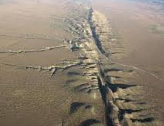
 Scientists quickly determined that the CO was coming up out of the earth; being expelled out through seismic faults.
What this means is the earth began moving in such a way on February 26, that pressure along the fault lines became so great, it expelled massive amounts of naturally-occurring carbon monoxide gas from underground.
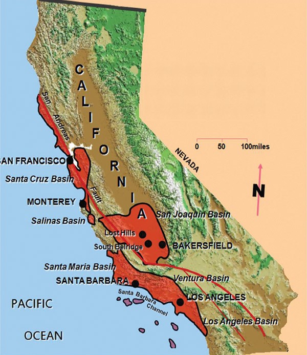
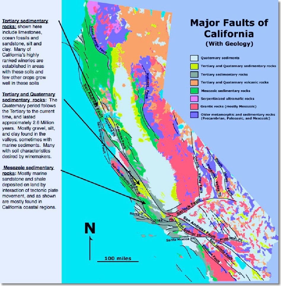
In fact, the proximity of the CO emissions directly aligns with what are known as the Monterey Formations, which are shale formations holding oil and gas! The gas is contained within the shale rock, but is being squeezed so hard, the gas is being forced out. That’s a LOT of pressure to squeeze gas out from inside rock! The Monterey Formations appear on the image below in red:
When pressure builds up like this, it is not hard to understand that something has to “give” and when it does, there’s an earthquake. That’s why this emission of Carbon Monoxide is believed by some scientists to be a warning sign of an impending, LARGE earthquake.
| The last time an emission of Carbon Monoxide on this scale took place, was a week prior to the Gujarat Earthquake which devastated India; killing twenty thousand people and destroying 400,000 homes when the 7.6 quake struck in Jan. 2001.
Another quake, far worse in China in 1978, had similar gas emissions, detailed below . . . |
Emission Easing, But Still Spewing in Several Specific Areas
After the initial emission of CO on February 26 into the 27th , winds began to dissipate the CO and carry it eastward, thinning it out as it traveled. Here is the satellite image from 12:00 Noon eastern US Time today (29 Feb 2016):
This easing of emissions can mean one of two things:
1) The pressure has receded and the danger is less, OR;
2) The pressure squeezed almost all the CO out and there’s simply not much left to push out; meaning the quake danger could still exist or be growing!
The simple fact is, we just don’t know which is the correct answer, and the scientific knowledge does not yet exist to find out!
As you may notice, while the initial satellite image above clearly showed gas being emitted from the Cascadia Subduction Zone off the coast of Vancouver, BC as well as Washington and Oregon in the US, all the way down to San Diego, CA, three specific areas continue to spew large amounts of Carbon Monoxide to this day. These areas directly coincide with three major seismic faults: The San Andreas Fault, The Melones Fault and the Elsinore Fault as illustrated on the map below:
Below is today’s satellite image of the faults still emitting CO as shown in the red circled areas below:
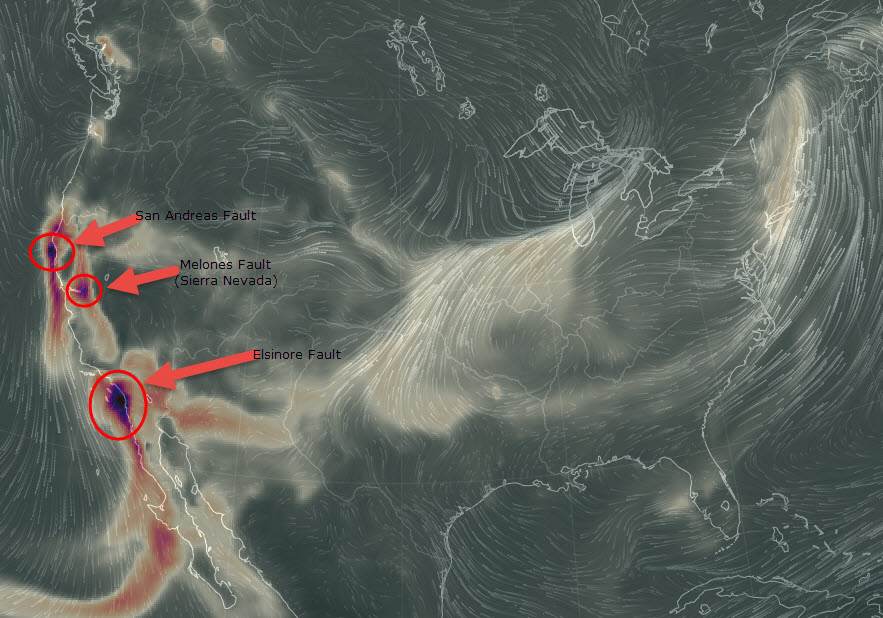
The fact that some of this CO is emanating from the Melones Fault Zone is problematic. There is no Monterey Formation there; the fault abuts the Sierra Nevada Mountains. For a fault this far inland to be emitting CO while faults farther to the west (San Andreas) and south (Elsinore) are also exhibiting this same activity, gives an indication of the utterly massive amount of tectonic pressure taking place and the ENORMOUS area being affected by this tectonic stress.
 If history is any indication of future activity, then, as took place in India in 2001, at some point within the next six or seven days (max) – there may be a **** MAJOR **** earthquake along one or more of these fault lines. This is NOT certain so DO NOT PANIC.
If we doubt that such gas emissions may be related to earth quakes, and think perhaps the gas emissions just prior to the 2001 quake in Gujarat, India was a mere coincidence, bear in mind that India was not the only major quake where gas emmissions took place in advance.
CHINA
No other earthquake in the 20th century was as catastrophic or claimed as many lives as that which struck the city of Tangshan in Northern China on July 28, 1976.
Tangshan, a thriving industrial city in Hebei Province is located about 95 miles east and slightly south of Beijing, and about 280 miles southwest of Haicheng (Liaoning Province) – where in February 1975 another very destructive earthquake had occurred.
Although the region had experienced moderate seismic activity in the past, there were no foreshocks and no advance warning.
Date and Time of Origin: July 28, 1976 at 19:42:53.8 UTC (local date and time: July 28, 1976, 03:42).
Epicenter: The earthquake occurred near the coast, in Tangshan in the Hebei Province of northeastern China. Its epicenter was at 39.60° N 118.20° E, about 140 kilometers southeast of Beijing.
Magnitude: Originally reported as 7.8, later revised to Mw 7.6
Focal Depth: Shallow, 15 kilometers
There were no foreshocks or clear precursory phenomena prior to the Tangshan earthquake – as there had been in other earthquake stricken areas of China. However, more than half a month earlier there had been a series of abnormal signs observed in the regions of Beijing, Tianjin, Tangshan, Bohai and Zhangjiakou. Based on such signs the State Seismological Bureau had correctly concluded that a significant earthquake could be expected between July 22, 1976 and August 5. However, the precursory phenomena differed from those of other earthquakes. Because of the scattered distribution of the signals, there was no determination of the location where this earthquake would strike.
Related: 50 Critical Items to Survive Disaster
Just prior to the earthquake, many unusual phenomena were observed in the immediate Tangshan region. There were observations of large amplitude variations of groundwater level and of strange animal behavior. As early as July 12, it was reported that gas began to discharge from a well in a village. On July 25 and 26, this discharge increased. The day before the earthquake, well water at another village, reportedly rose and fell three times and other wells showed signs of cracking of their lining. . . (Source Here)
Death Toll – Within seconds of the earthquake, thousands of people lost their lives or were trapped in debris. The actual death toll from this earthquake may never been known with certainty. According to official government accounts the earthquake killed 242,769 people and severely injured another 169,851. However, based on the density of the population and the extent of destruction, these figures have been disputed. At the time Tangshan had 1.6 million inhabitants. Since the earthquake destroyed ninety three percent of all residential buildings, the death toll was estimated to be three times greater than what was reported – ranging from 655,000 to 779,000 people.
NO PREDICTION, JUST COMMON SENSE
This article is not a “prediction” or some sick Hoax. It is a logical assessment of the facts as they are known, using data sources which are reputable, which form the basis for a logical conclusion. Quite simply, we have compiled this information and ask you, the reader, to apply common sense. There is NO REASON TO PANIC, but there is reason to pay attention and THINK if maybe you should make some preparations, “just-in-case.”
We must emphasize that, at present, modern science CANNOT accurately predict an earthquake. We certainly do not claim to be able to do so and are NOT doing so!
Having said that, it is undisputed that the last time this type of CO emission took place, twenty thousand people were killed by a magnitude 7.6 earthquake in India and the time before that, at least 242,000 were killed in a quake in China where gas was emanating days in advance.
Therefore, it seems prudent to us, to publish this information so people throughout California can decide for themselves if emergency preparations are necessary.
SUGGESTED PREPS
Put fuel in your car gas tank and keep it topped-off for the next week or two in case evacuation becomes necessary. You don’t want to wait until a quake hits before trying to get fuel – which will be almost impossible to obtain if disaster strikes.
Have a supply of fresh water to drink and cook with for fourteen days. (Never mind for washing or flushing toilets – we mean water for SURVIVAL). Each human being requires six to eight (8 ounce) glasses of water per day. That’s 1/2 gallon per person, per day
Have a small, gravity-fed water filter. You may need this because in a major earthquake, municipal water mains may rupture; leaving entire cities without water. You may have to get water from a local stream, river, pool or lake. If you have to get water from such places, filter it first before drinking or cooking with it! With a water filter, you’ll need a storage bucket or containers to store the water you filter. So have a clean bucket or clean containers on-hand.
Have canned foods (soups/meats/beans/fruits) or dried foods (rice/pasta/grains) that will not spoil in the absence of electricity – and a MANUAL CAN OPENER to access that food.

Have basic emergency gear like battery operated flashlights and radios with spare batteries.
Have spare clothing to keep warm and dry if your home is ruined and you are forced to be outside for awhile.
Some of you may have, or want, an emergency electrical source like a small generator to provide limited electricity. If you get one, make sure you learn how to use it . . . AND NEVER, EVER, EVER, USE IT INDOORS. The exhaust gas from the generator motor will kill you if used indoors. Also, generators need fuel. Make certain you have only the lawful, safe, amount of properly containerized and stored FUEL to supply that generator. DO NOT STORE FUEL INDOORS, it could catch fire and make things worse. Be smart, not careless.
Those of you with outdoor propane gas grills, might want to make sure the propane tank is full or get a spare for cooking.
Of course, having some first aid supplies is a good idea to treat any cuts or bruises or to help someone seriously hurt by a quake.
Have a supply of medications that you may routinely take — and may need to rely upon for a week or two — until supply chains can be brought back online after a major disaster.
Much of this stuff can be packed into a “go bag” for each member of your family. Put the essentials in each bag (per person), make sure everyone knows where each bag is, and have a plan to grab the bags and meet at a particular place inside our outside your home if a quake hits.
We cannot say for certain that a major earthquake is going to strike. That’s why we urge you DO NOT PANIC!
What we can say that when this type of massive CO release has taken place in other places in the past, there was a major, deadly earthquake within a week. If it happened in the past, it can happen again.
DO NOT PANIC — PLAN INSTEAD
 The choice is completely yours as to how to use (or ignore) this information. One thing is certain: THERE IS NO NEED TO PANIC. But there may very well be a need to plan, AND PLAN FAST.
We urge you to plan, now. If the past is any indication of the future, within about six or seven days, we will all know.
Having supplies and not needing them is better than needing them and not having them. Prepare while you can. Your life may depend on it.
UPDATE MARCH 1, 2016 8:20 PM EASTERN US TIME — The following “Important Notice” has been issued by NASA:
IMPORTANT NOTICE: Elevated carbon monoxide (CO) concentrations over California in the GEOS-5 products since February 25, 2016, are incorrect. They are a consequence of unrealistic emissions derived from satellite observations of fires, which led to elevated concentrations of atmospheric CO (as well as other species).
NASA’s EOS-Terra spacecraft entered safe mode on February 18, 2016, during an inclination adjustment maneuver. This caused the MODIS instrument to enter safe mode, with the nadir and space-view doors closed. When the Terra MODIS transitioned back to science mode on February 24, 2016, the operating temperatures for the SWIR and LWIR (Short-wave Infrared and Longwave infrared) focal planes have not yet stabilized. As a consequence, some data products have been severely degraded. This includes the “Fire Radiative Power” fields that are used by GEOS-5 to compute emissions of CO, CO2, and carbonaceous aerosols by biomass burning.
GMAO is working to correct this problem. The GEOS-5 analyses will be re-run from February 24, 2016, using only the EOS-Aqua MODIS data, in order to exclude the unrealistic CO emissions. EOS-Terra observations will be re-introduced once the instrument has stabilized.
Just one problem: This Statement Makes No Sense
The statement issued by NASA makes no sense. Even if the satellite was placed into “safe mode” to be relocated and even if the doors had been closed for that move then re-opened, by NASA’s own admission, the doors were re-opened and the satellite put back in “science mode” on February 24.
The readings which we published were effective THREE DAYS LATER, on February 27.
Does NASA expect the world to believe that the instruments aboard their state-of-the-art satellite could not “stabilize” in three full days?
Further, the readings dissipated smoothly across the continental United States and continue to do so since February 28th. If NASA’s claim that the instruments were not “stabilized” then how can they explain the completely smooth, natural dissipation of the CO gas, in accordance with prevailing wind patterns over the course of several more days? It seems to us that if the satellite was unstable, that when it stabilized, there would be a sudden, discernable shift in its readings. That is not the case.
Next, the contention that the reading for “Fire Radiative Power” seems to imply that wildfires burning on the west coast, may have impacted the satellite reading. There are no massive wildfires on the west coast which would even come close to affecting the enormous area reflected by the CO emissions captured by the satellite.
Related: Emergency Kit Necessities: Surviving a Disaster in the City
SuperStation95 goes to great lengths to publish news that the mass-media does not, so as to inform readers in a responsible manner.
In our story above, we repeatedly told the public “DO NOT PANIC” making clear “THERE IS NO REASON TO PANIC” yet this story has been smeared by quak-like “experts.”
For Instance, a MyNorthWest.com story quotes John Vidal, director of the University of Washington’s Pacific Northwest Seismic Network, who actually told MYNorthwest.com that the reason for the CO detection is a high pressure system creating stagnant air loaded with CO and fires burning in various places like Canada. Mr. Vidal went on to make a complete fool of himself, to the point of quackery, when he stated:
Back in the 1970s, when we were looking at all possible ways to predict earthquakes, there was an idea that the Earth cracks up in the area about to have an earthquake. And when that cracks, fluid and gases might come out of the ground,” he said, noting that back then a theory emerged that watching for those gases could indicate where an earthquake was about to hit.
“But that was back in the ’70s. Now we know the ground doesn’t crack across the entire area and that idea just doesn’t work,” he said. “In the 40 years since, when we’ve been watching faults, we have tremendously improved measurements, and that kind of signaling just doesn’t come before big earthquakes.”
Apparently this “Director” never bothered to read the Scientific papers analyzing the release of Carbon Monoxide from the Gurjarat, India earthquake of 2001 . . . written by geophysicist Ramesh Singh, and published in the scientific journal:
Volume 25, Issue 4, April 2010, Pages 580–585
“Applications of fluid and gas geochemistry to geohazards investigation”
Had he bothered to expend _any_ professional effort before shooting his mouth off about our report, he would have found that this peer-reviewed, scientific paper established the following:
NOAA AVHRR images have clearly shown anomalous changes in land surface temperature associated with earthquakes in the past two decades. Soon after the Gujarat earthquake of January 26, 2001, an anomalous increase in land surface temperature was inferred from MODIS satellite data a few days prior to the main earthquake event. The cause of such an anomalous change in surface temperature prior to the earthquake is attributed to many probable phenomena, but no definite cause has been identified. In the present study, changes of a complementary nature were found of land surface temperature associated with the emission of CO from the epicentral region. The observed changes on land and atmosphere associated with the Gujarat earthquake of 26 January, 2001, show the existence of strong coupling between land, atmosphere and ionosphere.
But a lack of professionalism bordering on Quackery seems to be the norm on the west coast. The media out there is another example.
MyNorthwest “reporter” Richard D. Oxley who did this “story” never bothered to contact SuperStation95. Despite our email and telephone numbers being prominently displayed on our CONTACT page, young Mr. Oxley failed to perform even the most rudimentary journalistic task of contacting the source. And he has the gall to call himself a “reporter.”
SuperStation95 stands-by our story. We published it solely to inform the public so they could decide for themselves if any action was required. While we earnestly hope that no serious earthquake takes place on the west coast, we believe that alerting the public is what the media exists to do.
We will continue to report despite the fact that the mass-media seems grossly derelict in its duty.
by Newsroom